The plans for a drone air-traffic control system may set the ground work for bigger things.

It may be a year or more before the U.S. Federal Aviation Administration (FAA) changes its rules enough for Amazon or other hopefuls to deliver products by drones.
But the five-year FAA Reauthorization Act of 2018, signed into law Oct. 5, confirmed controversial rules the FAA considers critical to its ability to regulate drone traffic and confirmed funding and plans for drone-specific additions that would create an air-traffic control system that can track traditional aircraft and a rapidly growing population of commercial unmanned aerial vehicles (UAV).
The near-term goal is to provide safe, low-altitude operations for both drones and manned aircraft. The longer-term goal is to accommodate what is expected to be enormous growth in the use of commercial drones, in an efficient way, according to briefing materials from NASA.
The bill covers all aspects of the FAA’s operations, but the biggest change is the integration of civilian unmanned aircraft into the national airspace system using a NASA-designed network of tracking systems called the unmanned aircraft systems traffic management (UTM) system.
Most of the rules remain the same. Unless they have a commercial drone license that adheres to the FAA’s Section 107 requirements, drone pilots have to be flying for non-commercial reasons. They have to register their aircraft, fly only within visual line-of-sight, stay away from other aircraft, stay under 400 feet and avoid emergency response efforts.
The UTM is not designed as a homogeneous, centralized repository of real-time information on the current status of drones. Instead it depends on local Low Altitude Authorization and Notification Capability (LAANC) applications designed to automate the process of authorizing drones to use local airspace and tracking their locations.
LAANCs are operated by non-governmental UAS Service Suppliers, which will maintain the systems and make sure current data on the presence and activity of drones is shared through the UAS Data Exchange and represented on USA Facility Maps designed to keep drones, aircraft and other potential hazards out of one another’s way. LAANC was scheduled to be in operation in more than 300 air traffic control systems at more than 500 airports nationwide by the end of September.
Its role is to act as a central point of contact and information for commercial drone operators, hobbyists, air traffic control, law enforcement and anyone else interested in drone traffic.
Like other FAA programs, the UTM divides territory into different classes of airspace, depending on height and proximity to other potential hazards, such as an airport. Traffic management has to be able to identify aircraft in each zone and communicate with or influence them to move in a direction that is safe for all aircraft. The idea is straightforward, but dozens of questions remain about how to set priorities on different types of traffic, and different types of aircraft, while making those evaluations and decisions resulting from those priorities obvious to UTM operators, according to NASA.

Fig. 1: UTM operations in context of airspace classes. Source: NASA
The UTM, and the more recent lobbying of drone user consortia to encourage collaboration, represent a big change in position and in attitude toward drones at the FAA. It is less clear how much of that switch had to do with a change of personalities in management—former Administrator Michael Huerta stepped down when his five-year term ended in January, Deputy Administrator Daniel K. Elwell stepped in as Acting Administrator. It also could have something to do with the realization that the problem was a lot bigger than the FAA thought it was going to be.
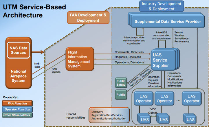
Fig. 2: UTM service-based architecture. Source: NASA
UAS service providers would have to provide basic integration and data services to connect traffic controllers to drone pilots, see and identify individual drones in flight, using an identification system that will be built in to each commercial drone to provide a unique ID, broadcast along with its reason for being where it is, to observers, air traffic control or potential victims of “confliction”
If the UTM works as planned, however, it will allow the FAA to reduce or remove restrictions on things the FAA has always forbidden for safety reasons—flying a drone beyond the point the pilot can see it, for example, flying it over people, flying at night, or flying with payloads to be delivered.
The FAA has another year to finalize rules that might allow Amazon or other service providers to develop and fly delivery drones.
Possible UAS services to be provided by third parties:
• Situational awareness updates
• Airspace authorization,
• UAS identification,
• Real-time aircraft tracking
• Conflict advisories
• Geofencing

Fig. 3: UTM hierarchical data flow. Source: Loup Ventures
“We view it as a system of systems,” according to Maria Scott, president of Skymap, a Verizon subsidiary that develops drone-traffic and management applications for companies large drone inventories. It’s a decentralized network like a wireless network or the Internet, to coordinate all types of aircraft.”
Details of how the UTM will work and who will build and operate it are a work in progress, despite two years of testing and a design framework from NASA. The FAA’s Reauthorization Act gives the FAA 18 months to come up with specific rules for a system to manage traffic up to 400 feet above ground level, as long as it meets these criteria:
• Protection of persons and property on the ground,
• Remote identification of aircraft,
• Collision avoidance with respect to obstacles and aircraft,
• Deconfliction of aircraft trajectories (crash prevention),
• Safe and reliable interoperability or noninterference with air traffic control and other systems operated in the national airspace system,
• Detection of noncooperative aircraft,
• Geographic and local factors,
• Aircraft equipage, and
• The qualifications, if any, a service provider would need to operate a UTM.
(To participate, respond to a federal RFI at FedBizOps, solicitation number UTM09032014.)
NASA predicts four stages in the UTM build evolution:
UTM1
Mostly show information that will affect the UAS trajectories
• Geo-fencing and airspace design
• Open and close airspace decision based on the weather/wind forecast
• Altitude rules of the road for procedural separation
• Basic scheduling of vehicle trajectories
• Terrain/man-made objects database to verify obstruction-free initial trajectory
UTM2
Make dynamic adjustments and contingency management
• All functionality from build 1
• Dynamically adjust availability of airspace
• Demand/capacity imbalance prediction and adjustments to scheduling of UAS where the expected demand very high
• Management of contingencies—lost link, inconsistent link, vehicle failure
UTM3
Manage separation/collision by vehicle and/or ground-based capabilities
• All functionality from build 2
• Active monitoring of the trajectory conformance inside geo-fenced area and any dynamic adjustments
• UTM web interface, which could be accessible by all other operators (e.g., helicopter, general aviation, etc.)
• Management of separation of heterogeneous mix (e.g., prediction and management of conflicts based on predetermined separation standard)
UTM4
Manage large-scale contingencies
• All functionality of build 3
• Management of large-scale contingencies such as “all-land”scenario
Source: NASA
Even for tech providers who don’t compete in the market for the drones themselves, the ongoing cost of traffic management could be worthwhile market, according to a report from UAV-business analysis firm Unmanned Airspace. Spending on the startup version of the UTM will be “modest to say the least,” according to the report, which goes on to estimate that traffic management services for drones will be worth $517 million between 2018 and 2022.
Minneapolis-based venture capital firm LoupVentures, however, predicts UTM service providers will have to charge drone operators a fee of between $100 and $300 per aircraft per year starting in about 2020, when there will be about 414,000 commercial drones flying in the U.S. By 2030, the firm predicted, there will be as many as 10.8 million drones using the national airspace compared to about 280,000 manned aircraft flying regularly.
Drone ID
The FAA hasn’t decided which of several drone ID schemes to use. It may use the Remote ID specification it announced in 2016, or integrate that with with Open Drone ID from Intel, or add some integration with DJI’s “license plate” called Voluntary Flight Identification Option, which integrates with its Aeroscope geofencing capability.
It is unlikely the FAA will go for a proprietary specification from the Chinese-owned DJI, however, even though the company owns 74% of the micro-UAV market, according to the most recent Skylogic survey from July of 2018. DJI is also one of nine new LAANC service providers approved by the FAA to provide data for UAS facility maps
“Remote ID isn’t the only thing needed to make drones more secure, but it is a necessary aspect,” according to Lisa Ellman, an attorney with the Washington Law firm Hogan Lovells who is also co-executive director of the Commercial Drone Alliance, which is campaigning to get the FAA’s hobbyist-friendly Section 336 repealed.
“At the simplest level if you see a drone flying where it shouldn’t, or doing something it shouldn’t, how do you know whose it is? Is it a careless citizen, or a criminal? It’s important to the future of innovation for all the drones to be identifiable without a burdensome requirement,” Ellman said. That’s why people were watching the FAA bill so closely to see the issue was resolved before the bill was signed.
Having a defined set of rules—or mostly defined—will be a huge step up for people interested in commercial drone services, according to Colin Snow, CEO and founder of Skylogic Research LLC, which conducts a large-scale survey of drone users in an effort to gauge the size and composition of the commercial drone market, and its major concerns for the year.
Until the reauthorization bill passed, one of the biggest concerns focused on the glacial speed of change at the FAA and the real chance that the agency might reverse itself on a critical decision and kill a nascent commercial service in the process.
“Every industry is perplexed about the consistency of regulation and enforcement,” Snow said. “This a big reason there is a lot of caution about commercial services. How much potential do drones have for economic benefit? That depends on business investment, and I don’t know how much businesses want to invest in drones. For lots of reasons they’re still trying to figure out how to adopt them and use the data,” Snow said.
“The FAA put out statements saying they’re all in favor of states putting regulations on drones, because some of them are also a local issue,” Snow said. “In Newton, MA there’s a case where they put a restriction on drones flying below 200 feet; well, that’s illegal. The FAA has regulatory power over the airspace, but it does nothing to enforce it. So, does Newton own the airspace from 200 to 400 feet, and the FAA gets what’s above that?
“On the commercial side, the growth isn’t where everyone thinks it should be, mainly because of the regulatory issues,” according to Michael Blades, an experienced military pilot, expert on drone use and technology and research director, Aerospace, Defense & Security North America for Frost & Sullivan. “Drones are cheap and easy to fly, that makes them much more attainable for the average person at Best Buy.
“You do need to know where you stand when you go into business with them. But I don’t fault the way the FAA’s doing things,” Blades said. “Their charter is not to make people money by letting drones into the national airspace; it’s to make things safe from the ground up.”
The drone market offers a lot of opportunity and drone businesses are already flourishing. Can the FAA’s system handle the amount of data and traffic?
The FAA’s system will have to be able to handle the 2 million to 4 million drones that are flying in this country already, and scale to handle about 7 million drones by 2022, according to current FAA predictions of growth. Those millions are the subject of a report published in July by Teal Group. drones will also generate income—about $82 million per year in drone-enabled business services according to the Another Teal report with a more recent prediction also breaks sales down into categories—one for commercial pilots and one for recreational. $4.4 billion globally this year to $13.1
“We expect growth across the board as the FAA allows more access to air space, but the places that will really take off are areas that involve a lot of inspection,” according to Philip Finnegan, director of corporate analysis at Teal Group. “Think of construction, oil and gas, mining, insurance, agriculture—those are all areas primed for growth.”
With a reliably positive growth curve and a five-year reauthorization road map to give developers confidence, we’re likely to see a lot more competition in critical cognitive-computing functions such as object avoidance and detection in drones, Finnegan said. “No one’s there yet and it’s not clear how it’s going to be resolved technically, but anticipatory object recognition and avoidance will be critical,” Finnegan said. “DJI has a system that’s fine for avoiding a tree, but if you’re dealing with an airplane, which moves fast enough that a UAS may not have the power to avoid it. There’s no system out there that solves that problem yet; even if there were, we would have to establish standards for safety and performance and traffic management.”
Concerns about security are likely to go beyond the FAA’s concern that a drone will fall on someone. Amazon Prime Air may not be able to deliver in the U.S. yet, but Amazon did pick up a patent in 2016 on a method to prevent hostile takeover of drone in flight during package delivery.
Delivery drones don’t create or pose as great a risk as the (allegedly) CIA-controlled RQ-170 Stealth drone that crashed 140 miles inside Iran in 2011, and which the Iranian military claims to have reverse-engineered to produce its own stealth drone. But every company has its secrets, so it’s better to make sure there is good enough encryption, tamper-proofing and physical security to keep anyone who captures delivery drone from getting to the PKI certificates customer locations and credit-card numbers or other sensitive information, according to Richard Newell, senior principal product architect at Microchip Technology (formerly MicroSemi). “You want to be sure it’s no good to them even if they bring it back to the lab,” he said.
 |
 |
 |
|
 |
|
 |
Leave a Reply